The Many Faces of the American West: Tahoe to Texas
What does one think of when one thinks of the American West? Cowboys and cactus and Hollywood, for sure. But there is all this and so much more.
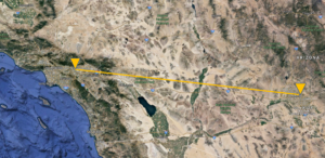
This road trip over the next week or so is via highway, not byway. The main stops are Tahoe to visit a friend; Pasadena for the Cassini Grand Finale and then onto Houston via Route 10, where I will leave for Ireland.
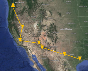
Road Trip! This is the path I took from Seattle to Houston, which is the jumping off point for Ireland. From Seattle to Reno: Nonstop drive: 721 miles or 1160 km; Driving time: 12 hours, 9 minutes
Tahoe
Heading south from Seattle to Tahoe, Route 44 cuts through Lassen National Forest, southeast towards Reno/Tahoe. It’s a two lane road, winding through forested land, gaining elevation along the way. It is fire season and smoke from the Oregon fires completely obscures the countryside. My heart goes out to the people living with the smoke and the uncertainty that wild fires bring.
Fire brings back memories for most of us who have lived in the American West. Living at the edge of town with the Sierra wilderness a block from my house, I’ve had several close calls with wild fires. The most recent, a few years ago, is still fresh in my memory.
A strong front with 60+ mph winds (over 100 mph at the ridge tops) was moving through the area. Living in the lee of a mountain range, such winds were not uncommon, particularly in the winter months. This night, I woke about 2 or 3 am, sensing something wasn’t right. In the haze of half sleep, I struggled to make sense of my instinct. The room had a slight glow to it.
The power was off. The only light was a deep hued reddish glow in the room. Nothing made sense to my sleepy mind.
Then I smelled smoke.
The backyard was fine. My house was ok. I stood on my bed, to look out through three small square windows high on the wall which looked west toward the Sierra. A liquid wall of fire streamed over the ridge just behind my house, running downhill, getting closer and closer. I stood mesmerized. Winds were howling; the fire was moving. Then I realized. I needed to get moving as well.
In the dark, I sought out the numerous flashlights I kept for for such occasions and I positioned them around the house. Howling winds often meant a loss of power. I had learned to be prepared.
My first thought was to get the cats. In the dark. In the smoke. Somehow I was lucky enough to nab both of them. They both went into the large carrier.
Computer; key files with passport etc. Clothes for a day or two and hopefully I’d be back. In the past, I’d packed half my house as a fire approached. That is not an option today.
The cars that belonged to my neighbors in the cul de sac were gone. They’d obviously cleared out. How had they known? Why hadn’t they called? Welcome to Reno. After over a decade living here, people were still clannish and kept to themselves. I was on my own, facing an out of control wildfire raging down the hillside.
I loaded the car. Without electricity I released the garage door so I could manually open it. In the dark it’s hard to maneuver, and it is heavy.
With the garage up, I realize the severity of the situation. The wind is howling, burning debris and embers rushing by, large trees swaying viciously in the wind. The fire line is rapidly moving down the mountain.
I can hardly stand, the wind is so strong. Cars with their headlights on are making their way down the hill in single file. One neighbor has simply opened their coral and let their horses run loose. There is no time to hitch a trailer.
From that day on, for months, everytime time the winds started to howl, I felt nervous. The wind alone, pounding the house and thrashing the trees, could often do that. But now the experience of wind and fire together were indelibly imprinted on my sense of being.
This year this trip from Seattle to Houston in 2017, is also punctuated by fire. Much of Oregon is burning. The smoke along I-5 is so thick I cannot see the hills along side the road. I consider whether it is wise to even leave the highway given the random scattering of fires spreading out of control, but cutting through Lassen to Susanville, shortens the drive by over an hour.
The road passes devastated countryside, followed by patches of forest that are utterly untouched. Charred branches and trunks remain where there was once lush forest. The only new growth is cheatgrass, so this fire was relatively recent.
Large trailers carrying massive logs occasionally slow my progress, but other than that, the smokey trip is just a part of life in the west, particularly this year. I downshift to pass a final logging truck heavily laden with tree trunks lashed to the flatbed, the road opens up and the smoke starts to lift. Rays of sunlight illuminate particles suspended in air, creating a flickering stream of light from sky to earth and earth to sky. The center line of the highway pushes ahead, a clear path forward. And overhead, the sky finally appears. Blue. Tahoe blue.
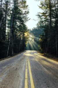
Photo by Pranam Gurung on Unsplash
As I come out of the mountains, I approach Reno from the north. The high desert is hot and barren. Mile after mile of desert passes me by. There is nothing but desolate land until the outskirts of the city start to appear.
And just one word comes to mind: “Scorched”.
Perhaps it’s simply the approach from the north where I clearly see what a small town in the desert this really is. Perhaps it’s the realization that for hundreds of miles, for many people, this is IT. The city: civilization.
“Change the way you look at things and the things you look at will change.”~Wayne Dyer
Were I to approach from the south, from Tahoe, I would have driven from a summit of 8,911′ on Mt. Rose highway to the valley floor at 4,500′. It’s a breathtaking, two lane mountain road that starts off in an Alpine environment and ends in high desert. It’s a drive that merges the best of the Tahoe National Forest with the fields and foothills that lead into the affluent Reno suburbs. It’s a view that takes your breath away.
But today, coming from the north, the only word that comes to mind is “Scorched”.
***
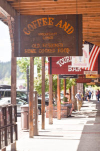
I take a full day and plan a final tour of Tahoe before leaving for Pasadena. I start with Truckee, where my I first encountered Tahoe more than two decades ago.
Truckee is just off Route 80. It was originally called Coburn Station after a local salloon keeper. The current name is derived from a Paiute chief who greeted the first Europeans yelling “Tro-kay”, which is Paiute for all is well. (Wikipedia).
Like all tourist areas, Truckee has an ebb and flow of people. This year, on this perfect September weekend, tourists crowd the sidewalks, restaurants and shops. From a locals perspective, it is time for the visitors to leave Tahoe. They have monopolized the lake for months now, with loud radios and speedboats, often leaving their trash behind on pristine beaches. September belongs to the locals. The days are sunny and warm, the water still holds onto some of its summer heat; and the cooling temperatures of fall start to descend.
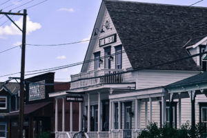
Truckee is bisected by train tracks from the Transcontinental railway built in the 1800’s. The train offers a ride back in time, through the Sierras to San Francisco (the train ride actually ends in Oakland and a bus transports passengers across the Bay into the city).
The original Transcontinental tracks were laid by Chinese laborers who were imported for cheap labor. Building the tracks required tunneling through the Sierra, a slow, tedious and often dangerous job. Wooden sheds protected the finished track from heavy snowfall. The Transcontinental Railway was completed on May 10, 1869. Today, you can hike the tracks in the mountains above Donner Lake.
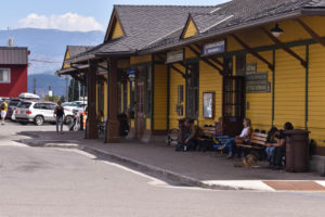
The Truckee Train Station
I stop for lunch at a newish seafood place I’d read of. It’s located across the tracks, behind the train station. It was sadly disappointing.
Main Street, Truckee CA
On the hill over looking town is a restaurant where I spent many a night with friends. At least it’s still there, but I don’t care to look too closely.
Part of the reason for this foray was to take pictures for this blog. But I realize that there was a much deeper need for me to revisit one last time. To see the last two decades of my life from a current perspective. Did I make the right decision moving to Tahoe? Did I make the right decision leaving?
“As you start to walk out on the way, the way appears.” ~ Rumi
Restored buildings become art galleries and restaurants in Truckee, CA.
I drive up to the Ritz Carlton at Northstar with the idea of savoring the massive slope side patio one final time, at least for now. But I am disinterested and decide against stopping.
Across from Northstar is Martis Creek and the Truckee airport Down a winding road is the soaring operation and a campground for pilots only. I turn down towards the airport that had once been a source of adventure, discovery and joy on my aviation themed trek westward.

A western variation of a stop sign!
I pull up to the airfield and there is no WHOA sign. The quirky stop sign with that western flair that Les had installed at the end of the dusty road to the soaring operation is no longer there. That WHOA sign was a symbol of the serendipity of travel. I came, I whoa’d, I flew. Absent Les’ quirky sign and friendliness, would my fate have been different?
Aside from the absence of the signage, not much has changed at the airport over the last two decades. Airports are clannish and cliquey; seldom welcoming.
I get out of my car and walk over towards the runway where I pause and watch a plane launch. It’s a ride. I can tell by the actions of the people and the datedness of the plane.
A young woman walks back from the launch to the airport. She barely nods. I am not of interest, either as a threat or a curiosity. Her sure steps back to the main hut shows that she has a place here, at this field. I see my younger self in her. I too had to fight to prove my airmanship and find my place in the aviation hierarchy. I understand.
A lone sailplane tied down at the end of the runway, waiting to go fly.
I had considered stopping at the Lone Eagle for one last look across this magnificent lake. But I just want to leave. Instead I stop at a tourist overlook, a spot I’d normally drive by.
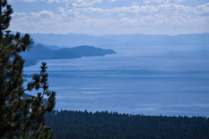
A view of Tahoe from an overlook off of Mt. Rose highway, above Incline Village, NV
It’s beautiful.
Its stunning.
But it’s not mine anymore. It doesn’t offer the posibility it once did. I used to think that if Tahoe didn’t wow me, something was wrong with me. But Tahoe will always wow me.
It’s just time to move on.
***
Tahoe to Pasadena, CA
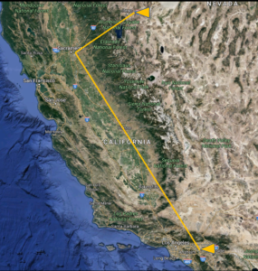
Reno to Pasadena: Nonstop drive: 473 miles or 761 km; Driving time: 7 hours, 36 minutes
Some people are drawn to cities or culture. Some to shopping. Geography draws me.
The West is a different country from its eastern brethren . It is shaped by the geographic imperatives of the land. Everything is on a large scale. The skies can go on forever and in some areas the distances between civilized enclaves is substantial.
Then there is the frantic, competitive energy of urban areas, such as L.A. and the Bay Area. In L.A. towns merge into a continuous city, from the mountains to where concrete meets ocean. Each area has its own social mores, from Hollywood to Venice Beach.
In the Bay Area, tech and money are the ruling clique, particularly in Silicon Valley. I recall attending a talk by Chamath Palihapitiya of Social + Capital Partnership at Google when I was looking to get my foot in the door to raise capital for ThinkTLC. A black woman, an MD, asked how one gains access to the various VC (venture capital) groups, most of which are located around Sand Hill Road. Chamath responded that “unless you are white, male and Ivy league (that includes Stanford and Berkley in this community) don’t even bother visiting Sand Hill Road. You won’t get funded.”
Where does that leave me, I wondered. White, female, and Ivy League. The black M.D. and I exchange glances.
“Achievement has no color.” -Abraham Lincoln
Looks like the Sand Hill crowd is a bit behind on this one.
***
L.A. and Pasadena are a good day’s drive from Reno/Tahoe. The Cassini Grand Finale at NASA awaits and Pasadena holds good memories, of the parade, times with friends, country club dinners and great wine.
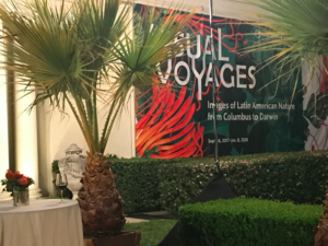
Pasadena is about a 15 minute (traffic free) drive to NASA JPL where the Cassini Grand Finale will be held. Carmen, my host and friend, lines up a wonderful few days, of dinner at Annandale Country Club and a fabulous evening at the Huntington Library celebrating the opening of a spectacular collect of Latin American exploration and culture.
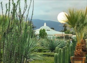
An evening of celebration at the Huntington Library.
The entry into the Huntington exhibit.
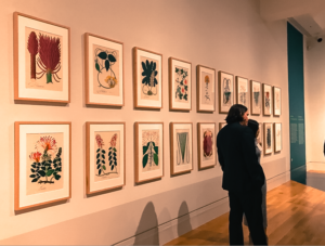
Inside an amazing array of art on the walls and on display cases makes for a most interesting evening.
So it is that I divide my days between space exploration at NASA JPL and history at the Huntington Libray, plus of course, some wonderful food.
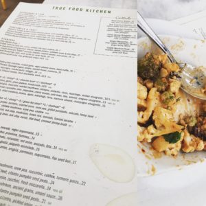
True Food Kitchen in Pasadena, where healthy road food feeds my culinary soul.
I love visiting Pasadena, and am tempted to linger, but I take off for Ireland in less than a week, and I need to get to Houston. It’s time to head east in my tour of the west.
Pasadena, CA to Scottsdale, AZ
Pasadena to Scottsdale via I-10 Nonstop drive: 386 miles or 621 km; Driving time: 5 hours, 56 minutes
Traveling I am grateful for Google maps and my Apple watch which gives me a mild electronic buzz on my wrist when it’s time to turn this way or that. Navigating without these aids would be difficult. But I think I need to be able to reprogram the map interface a bit.
Every time I stop for gas or coffee I am admonished in a flat electronic voice to “Proceed to Route”, as if this minor foray is simply not permitted. My watch gives me a mild electronic zap to remind me to obey and turn as directed. Sometimes I think it’s fun simply to drive in circles and listen to Google go tech turvy as it tries to recalibrate my route.
On the stretch to Scottsdale, I simply turn off the navigation. It is a simple route, directly east to Phoenix and I’m not inclined to be admonished should I deviate from the route.
There is something about the aesthetics, beauty and orderliness of Scottsdale that I always enjoy. In the winter the weather is beyond fabulous. In the summer it is unbearably hot. Out of season, this September, Scottsdale is very reasonable. I stayed in a property that was a bit dated but fully renovated, with lovely suites that included a sitting/work area, a small kitchen and a separate bedroom and bath. Mornings the chef custom cooked omelets, which allowed me to eat reasonably, if not perfectly, on the road. The ingredients weren’t organic; the eggs most likely not organic, free range or omega 3 rich, but still, a viable road food option with some vegetables to boot.
For lunch, however, I head to True Food Kitchen.
True Food is a regional group of restaurants started by Harvard physician Andrew Weil, MD. Dr. Weil has been a bit of a renegade in the medical world, advocating common sense good health through nutrition, exercise and similar avenues over traditional medicine’s almost exclusively pharmaceutical approach. Needless to say, I admire his guts in taking a road less traveled. And I adore his restaurants which feature locally sourced, responsibly raised, organic ingredients.
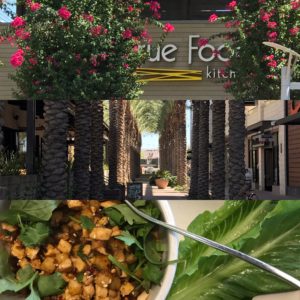
True Food, Scottsdale | The Palm lined walk to the restaurant | Lunch!
Lunch this day was the slightly spicy and totally delicious lettuce wraps, which was enough food for two people. The total bill: $10.80. Eating healthy will definitely not break the bank.
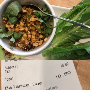
A lunch at True Food Kitchen in Scottsdale, AZ.
Scottsdale combines modernity with soul. The shopping is outstanding, if you are so inspired. I personally indulged in a bit of retail therapy at the sale rack of Eileen Fisher to fill in a few gaps in my travel wardrobe.
Retail therapy at the sales rack at Eileen Fisher.
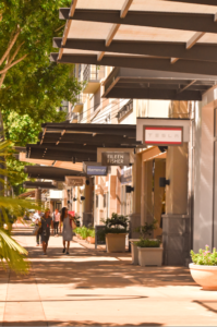
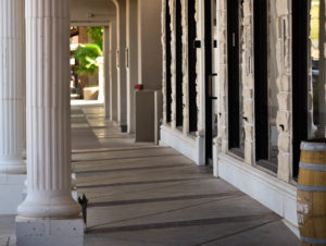
While Scottsdale has a facade of commercial glitz, it also has some soul. The Old Town at the south end of town was founded in 1888 when U.S. Army Chaplain Winfield Scott bought 640 acres for $3.50. Old Town is a collection of nice bars, galleries and restaurants. It’s also a spectacular place for morning walks with the sun low in the sky and the covered side walks offering a refuge from the bustle of the city and the upcoming heat of the day.
A shaded sidewalk in Old Town Scottsdale.
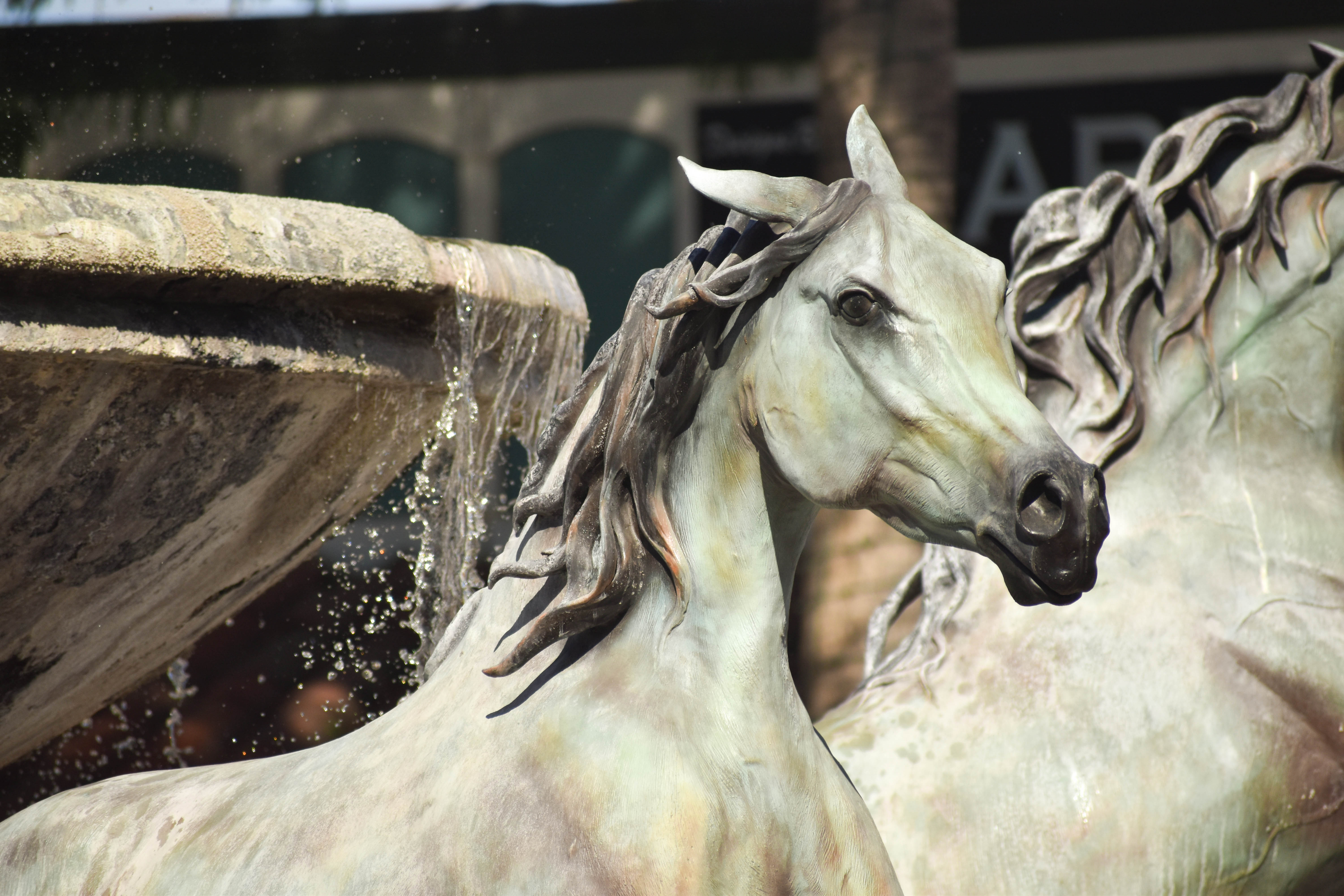
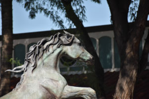
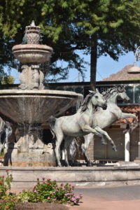
In one of the roundabouts is a spectacular fountain that includes four bronze horses. The horses look as if they could jump from the water into the street at any moment
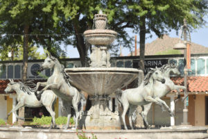
A fountain in a roundabout in Old Town Scottsdale.
The detailing is exquisite, and I take picture after picture, trying to capture the vibrancy of the sculpture.
Bronze statues of horses in the Old Town roundabout.
Details of two of the four horses.
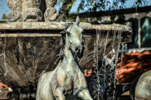
Each horse looks primed to jump from the fountain and disappear down the road.
Old Town is quiet in the morning. Baskets of flowers hang from the bridge over the waterway and splashes of color provide color and texture:
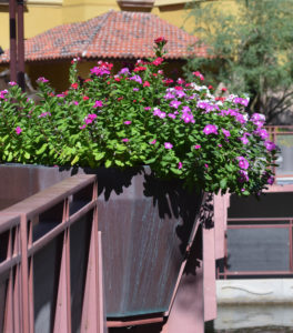
Flowers over the waterway, near Nordstrom’s in Old Town.
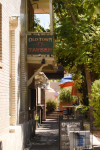
Old Town Tavern in Old Town Scottsdale.
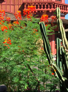
Cactus and plantings provide a blast of color in Old Town Scottsdale.
Scottsdale, AZ to Vail, AZ
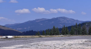
From Scottsdale, it’s a short hop ( about 2.5 hours) south on I-10 to Vail, AZ where I am visiting with some friends. Vail is just outside Tucson at 3,235 feet above sea level. Each one thousand feet is worth about 3 degrees of cooling, and in the Sonoran desert that translates into a more habitable summer. Winter monsoons dump vast amounts of rain in small amounts of time, so surprisingly, as one drives into the desert, it is actually green.
Vail is near the Saguaro National Forest, where the classic tree-like Saguaro cactus which is nearly synonymous with the American West, is found. These cacti can grow to over 40 feet tall and live to over 150 years old. Their size is determined in part by precipitation, and their age can be guestimated by the number of side arms growing out from the trunk. The sidearms typically start to grow between 75-100 years of age, although some cacti will never grow the distinctive appendage. Here area few pictures I shot in the stunning Saguaro National Park:
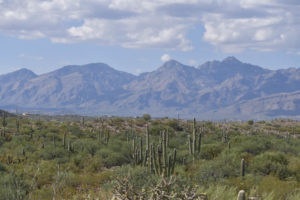
The Saguaro National Forest.
Clouds cast shadows on the distant mountains.
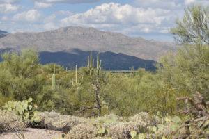
The Saguaro cactus are protected. These plants are massive, towering over the nearby terrain.
Should you decide to go, winters are wet from December through February, with snow at higher elevations. Summer rains from July through September tend to be heavier, with lightening and flash flooding. A storm can easily cool the desert by 20 degrees or more.
Summer temperatures range from 100-115 degrees during the day, and drop to the seventies at night. Winter temperatures usually range from the 60’s to 70’s, and drop to the forties at night. Occasional freezes also may occur. If this happens, you may see residents running out to cover their cacti, who don’t particularly care for the cold!
Vail AZ to San Antonio, TX
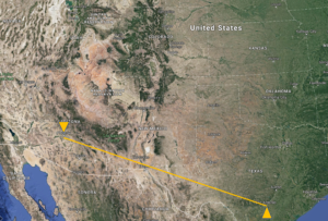
Tucson to San Antonio Nonstop drive: 868 miles or 1397 km; Driving time: 12 hours, 3 minutes
This is a two day trip, with an overnight stop in Las Cruces. The first day’s drive is easy, and I take a bit of time to stop and explore here and there.
Next to the road, a train travels alongside the highway. I easily pass the string of cars as they race straight ahead on their linear trek. It’s well past noon and I am getting hungry, and there doesn’t seem to be anyplace to stop.
A road side stop off of I-10
Just as this thought registers with both my stomach and my mind, a string of roadside signs appear advertising a trading post. Blankets! Knives! Moccasins! Food! The latter gets my attention. Any business willing to put up 20 or so billboards one after the other deserves a visit.
A woman greets me as I enter the large shop. Cases with jewelry, piles of clothes, a wall full of shoes and stacks of colorful blankets are piled everywhere. I simply ask for the food section, where I find dark chocolate covered almonds and cashews. Checking out, we chat. “Is there a place to stop for lunch?” I ask.
The two women behind the counter confer. There seems to be more than one possibility. But apparently the quality of the food at one place depends on who is cooking. Finally the women break from their huddle with a recommendation: Irma’s.
The directions sound concise but somehow I manage to mangle them. Google seems confused as well. But eventually I find the restaurant in a white brick building situated on the corner, just as it had been described.
I’m looking for something light, which in a Mexican restaurant may be an oxymoron. Browsing the menu I settle on huevos rancheros. This dish comes with a freshly made green salsa with hatch chilies. The pieces of roasted chili add depth, flavor and a bit of heat to the perfectly balanced green sauce. Yum. The eggs are perfectly cooked. The beans a bit banal, but I have no complaints.
Back in the car, my dark chocolate covered almonds have melted into a mound of goo in the Arizona heat. I navigate back to the highway. I need some road music. I come across a channel called “Texas Renegade”. Their tag line is “Nashville looks up to us.” Accompanied by some Texan twang, I put pedal to the metal and once again pass the speeding train.
San Antonio
Phoexix to San Antonio: Nonstop drive: 868 miles or 1397 km
Driving time: 12 hours, 3 minutes
The next stop is San Antonio. It is fall as I arrive, but Texas did not get the memo. It is hot, and it is humid.
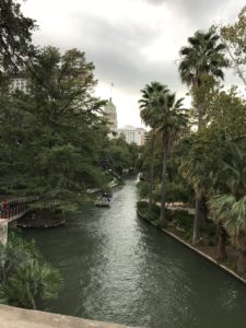
Riverwalk in San Antonio, as a major rain storm is brewing.
San Antonio is the 7th most populous city in the United States and the second largest city in Texas. It was founded as a Spanish mission and colonial outpost in 1718. Other missions were established along the San Antonio river in the 1700’s to further solidify Spain’s claims to the territory.
The Missions of San Antonio
Click here to visit the San Antonio Photo Gallery for stunning pictures of the Spanish missions!
The missions of San Antonio were a combination of religious centers and training grounds for Spanish citizenship. In exchange for the economic security of the mission, the Indians gave up their nomadic existence, and adopted the Spanish religion and culture. Sadly many succumbed to the European diseases imported by the Spanish, as well.
Each mission was a fortified village with its own church, farm and ranch. European technologies such as framing and blacksmithing were taught to the Indians.
Six missions along the San Antonio River were established. I was able to visit three of the Missions: the famous Alamo, Mission San Antonio de Valero; Mission Concepcion and Mission San Jose.
Mission San Jose
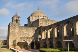
The church at Mission San Jose, in the morning light.
Mission San Jose is the most restored of the three missions thanks to a WPA work program from World War II. It provides a good sense of what mission life was like during the 1700s. At its peak, it housed 300 inhabitants.
The central grass square is ringed by human habitats–small rooms with a single entry– and enclosed by thick stone walls for protection. The walls were rebuilt from sandstone (rather than the original limestone) based on the footings found around the Mission.
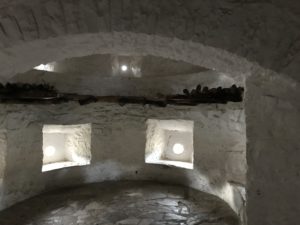
At the corner of the fortified Mission, openings below provide a place for cannon. The openings above allow rifles to extend out for defense.
The clock tower chimes as the morning light spreads across the stone walls. Here are a few pictures of this beautifully restored piece of history:
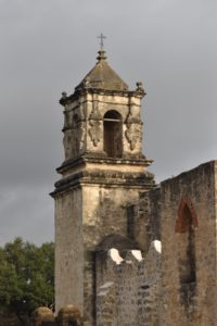
The bell tower chimes early in the morning, giving one a sense of what life in the mission must have been like.
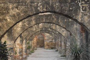
Arches create a loggia in front of the main church building.
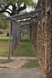
Residences lined the exterior walls. Each residence had an outdoor area where meat could be hung to dry.
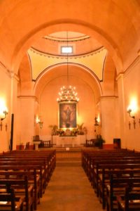
The interior of the church.
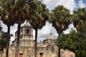
Mission Concepcion
Mission Concepcion is in its original state, not restored. The surviving stone detail around the main entry is stunning. Originally, wall art was used to decorate both the interiror and exterior. A replica of these frescos is on the side of the bell tower.
Looking for a bit of information, I stopped in the visitor center and chatted with the docent. I turns out she lived in Dublin for a time, and set about telling all sorts of stories. The rain in Dublin, she informed me was more of a mild mist. Not like Texas where “frog strangler rain storms” dumped a lot of water fast. I would witness a frog strangler storm later in the day as the overhead clouds burst and inundated everything in their path.
Palm trees provide some partial shade at Mission Concepcion.
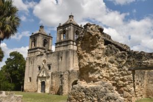
A side view of Mission Concepcion.
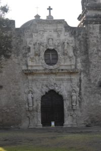
Detailed stone work on the front of Mission Concepcion.
Mission San Antonio de Valero (The Alamo)

The 1960 epic film about The Alamo, starring John Wayne.
“You will remember this battle! Each minute! Each second! Until the day that you die! But that is for tomorrow, gentlemen. For today, Remember The Alamo!” –from the 1960 film starring John Wayne
The Alamo was one of the original Spanish missions, but it seems to be best remembered as an epic war film depicting the 1836 Battle of the Alamo which was produced and directed by John Wayne, starring Wayne as Davy Crockett. Today, the interior court and other property that originally surrounded the mission are gone. Surrounded by downtown San Antonio, Mission San Antonio de Valero is a popular tourist draw.
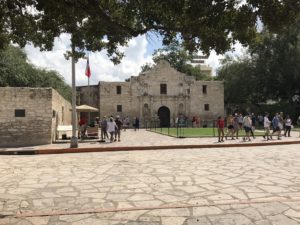
The Alamo, downtown San Antonio.
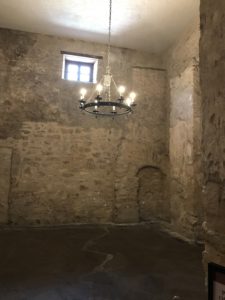
An interior room at the Alamo.
All this exploring, naturally, could not occur on an empty stomach and near the Mission Jose I stopped in a superb restaurant, Nicha’s.
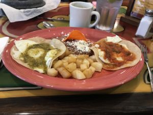
Delicious Huevos Divorciados at Nicha’s on Roosevelt Avenue in San Antonio
The Nicha’s story began in 1977 when Gene and Dionisia (“Nicha”) Garcia, opened a homestyle Mexican restaurant. The following grew and they eventually moved into their Roosevelt Avenue location, near the historic Mission San Jose. It’s a family restaurant, still run by two of the children.
The Huevos Divorciados (Divorced Eggs) that I had were off the charts excellent, as I suspect, is everything else on the menu. It’s actually worth planning a meal around this Mexican restaurant, where the food is very fresh, homemade and simply delicious.
The recipe calls for two eggs, with different but complimentary sauces. One egg is served with a green sauce, the other with a red sauce, both on homemade corn tortillas . Naturally some potatoes kept the two eggs apart, as is fitting Divorced Eggs. My eggs were accompanied by smokey beans which, I suspect, derived some of their deep, fabulous flavor from bacon, but I decided to overlook this departure from my normal diet and thoroughly enjoy the plate of food before me.
Nicha’s on Roosevelt Avenue. Don’t miss it!
San Antonio to Houston
This final leg is an easy drive. Why Houston? Because I leave from Houston for a trip to Ireland!!! There is a method to my madness, trust me. And stay tuned for the next series of tales from CancerRoadTrip!
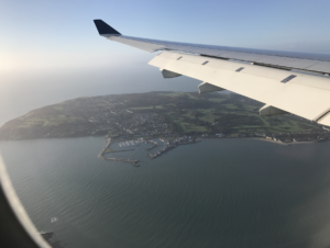
The Irish coast from the plane. Houston to Atlanta: 792.8 miles; Atlanta to Dublin, Ireland: 3,921 miles; Total Mileage: 4,713 miles
Like This Post? Pin It!
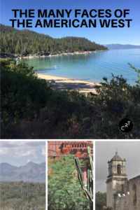
The Many Faces of the American West: A Trip from Seattle to Houston
If you’re interested in learning more about photography (or cooking or film or any number of topics) check out Masterclass for on-line excellence:

[et_bloom_inline optin_id=”optin_10″]
What is #CancerRoadTrip and how did it come to be? Read this post to get the backstory!
Follow me on Twitter, Pinterest, Instagram, and at Anti-Cancer Club. Connect with me! I may need a place or two to stay along the way!


I enjoyed your journey, Pat. Spent time in both Tahoe and Pasadena growing up. My maternal great grandmother lived in Camp Richardson on South shore Tahoe, my maternal grandmother in Pasadena, and paternal grandparents in Sierra Madre (Caltech connected family). Less experience with TX, although SanAntonio has been on my list for a long time. Thanks for sharing, and enjoy Ireland, which is also on my list.